My First Trip to Johnson Creek–Part 2

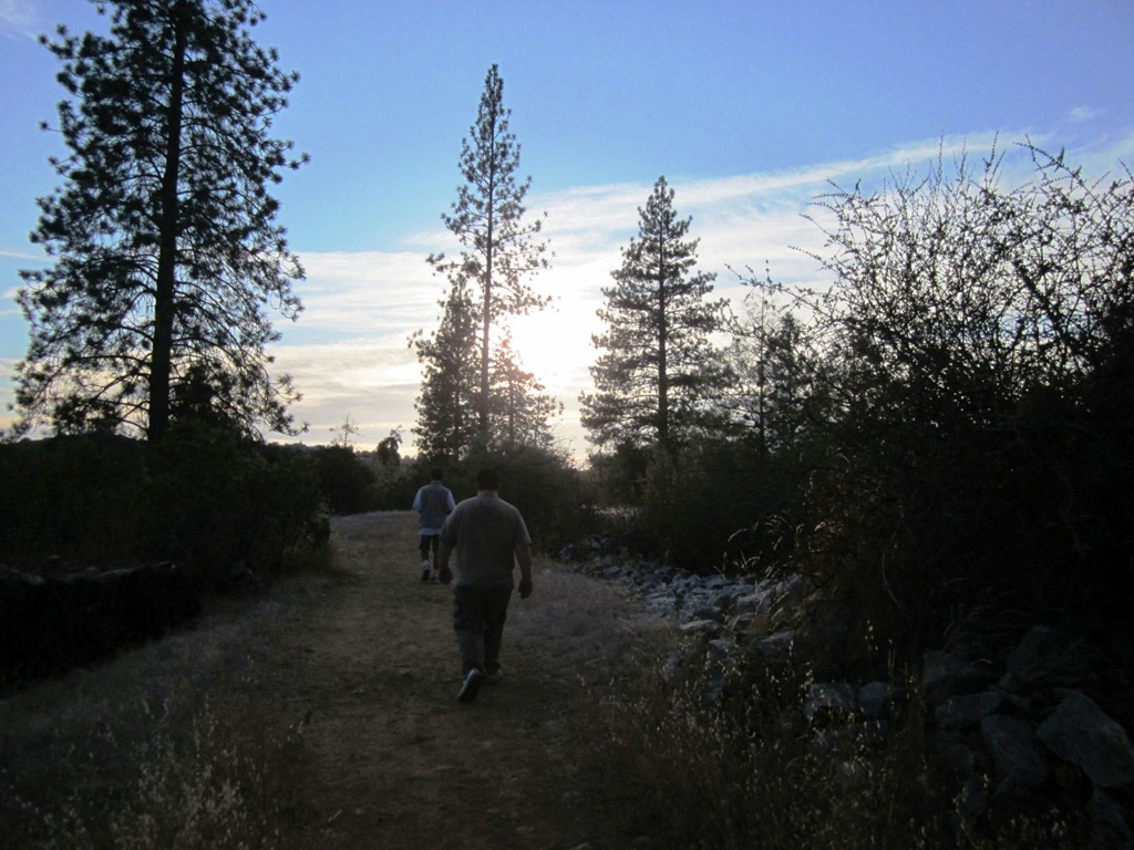
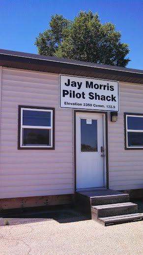
After enduring a sleepless night on a scratchy couch in an airport shack in Emmett, ID I was finally on my way to Johnson Creek.  The air was cool and still and as long as my vise grips held, I was certain I’d be sleeping in my tent this night.  I spoke to some locals in Nampa the day before and was told that the way they always flew into Johnson Creek was to head direct toward Warm Lake or Landmark (a USFS air strip) and then fly up the drainage (canyon) to Johnson Creek and that way I would be able to fly a fairly normal pattern, though it would be a tight pattern.

That’s pretty much how it went down.  Again, I had the sun in my eyes so it was difficult to see down in the drainages.  I found Warm Lake up on the ridge just south of Johnson Creek and adjacent to Landmark.  I crossed the ridge and then started to descend into the drainage.  It was still smooth as glass.  Soon Johnson Creek came into view and I was still a little high so I chopped the power so I could really get down into the bottom of the drainage. 

A friend had sent me an email the night before with some last minute instructions on landing at Johnson Creek which I kept reviewing in my head.  I knew I needed to get closer to the right side of the drainage, to stick my wing in the trees as it were.  The problem was it was all in darkness on that side of the canyon.  The sun was blinding me to what was there.  Soon I was in the shadow of the side of the canyon and I could see better.

The radio was letting me see what I couldn’t hear.  Plane after plane was departing JC.  Everyone was on their breakfast run.   I entered the downwind and announce my intention to land.  Two planes radioed back that they were rolling and would try to stay out of my way.  (Yeah!  My antenna really worked!)  I rolled around onto final into what would be an overshoot in a normal pattern, but at JC it’s SOP.  And here is where I ignored the advice given me.  I came in low over the trees at the north end of the strip and as soon as I had cleared them I chopped the power.  I touched down maybe 200 feet beyond the end of the runway and stopped maybe 300 feet later.  I had really underestimated how quickly the plane would slow down on the runway!  I added power and started taxiing up hill.  Then I came to my senses and thought, get off the runway stupid!  So I moved off to the side and continued my uphill slog.  Luckily there were no more planes either landing or taking off so I didn’t inconvenience anyone.

I pulled up next to a spot that had a tent but no airplane.  I tried to estimate about how much room an airplane would need and pulled in.  I went through my after landing checklist and then shut the engine down.  I sat in the cockpit for a few minutes with the doors open.  I took in the tree covered canyon wall in front of me, listened to the sound of Johnson Creek rushing by, the few birds that were in the area, and just let the adrenalin slowly drain from my body.  I wasn’t afraid on the approach, I was very alert, and now I was very elated!  I made it!

First order of business was to set up camp.  Once I had the plane positioned where I wanted it I set up my tent and pulled all my camping junk out of the plane.  Tent, check.  Chair, check.  Food, check.  Way too heavy tie-downs, check.  The plane was now empty, camp was set up.  Now I had two choices, fly out for breakfast or take a shower.  Since I was pretty sweaty and grungy from sleeping in the pilot shack in Emmett I decided to take the shower.  That turned out to be a VERY good decision.

Since everyone was either gone or relaxing (it was 0900 by this time) I located the showers and took a nice hot shower.  Afterwards I was out talking to some of the folks from NorCal when I saw everyone heading toward the north end of the field.  Some were jogging, some were running, some were walking.  I thought it must be some ritual that I didn’t know about.  I put my shower kit back in my tent and hung up my wet towel, no mind you, the required walking across the field.  I still didn’t notice what had happened.  Then I saw the wife of one of the NorCal guys and walked over to say hello.  That’s when I noticed. 

At the north end of the field two planes lay in a crumpled heap.  My first urge was to run down there to see if they needed any help.  But my first glance around told me that they didn’t.  With all the people swarming around they had more help than they needed.  I walked over to where the friends wife was sitting in the shade of a Maule’s wing and asked her what had happened.

The information came in slowly from different people but what had happened was there was another influx of airplanes coming in to land.  One was a Piper TriPacer, the other a Piper Arrow, not a Baron as reported in the news.  The TriPacer was struck from behind by the Arrow.  Neither one saw the other.  They collided between 40 and 60 feet in the air and fell in a heap.  The two men in the TriPacer sustained relatively minor injuries.  The man in the Arrow sustained more serious injuries and had to be LifeFlighted out by helicopter.  There was one passenger aboard the Arrow who did not survive the crash; the pilot’s 20 month old son.  He died shortly after being extracted from the wreckage.

Shortly after the crash we received word that Johnson Creek airport had been closed until further notice.  All the planes that had gone out for breakfast would not be allowed to return until the FAA reopened the airport.  This meant that 60 airplanes or so would have to find other placed to go in the mean time.  The day dragged by slowly.  I didn’t have much of an appetite and the only subject of conversation that day was the crash.  That didn’t help my appetite much either.

Finally at 7pm they reopened the airport and there was a rush of planes coming back.  Several times I thought we would have a repeat accident.  Maybe it was just my visual perspective.  Happily, there were no further incidents and everyone landed safely.  Including a couple of internet friends that I knew through my Rans affiliations.  Even though the airport was now a little more lively now that everyone had returned, the wreckage stood down at the far north end of the field as a somber reminder of the day’s events.

My First Trip to Johnson Creek Airport (3U2)–Part 1

For those who have never heard of Johnson Creek Airport it is considered the gateway to mountain flying in Idaho.  It is like the Ritz Carlton for back country aviators.  It is a beautifully manicured 3400 foot long, 150 feet wide grass runway near Yellow Pine, Idaho.  Never heard of Yellow Pine?  I’m not surprised, it’s a long way from anywhere.

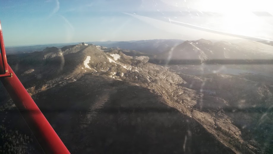
My day started at 0430 Pacific Time.  I had already packed my camping equipment in the plane and fueled up.  All I needed to do was throw my suitcase in the plane, update my weather briefing, and go.  I actually should have gotten an earlier start because as I was climbing out over the Sierras the sun was coming up.  This made the peaks particularly difficult to see as I was climbing almost directly into the sun.  As I leveled off at 9,500 MSL over Lake Tahoe I turned toward Lovelock, Nevada I at least got to turn to where the sun was hidden by a tube in my cockpit.

About two hours after I departed Oakdale I was landing at Derby Field, Lovelock, NV.  There isn’t much there other than an old MIG and a fuel pump.  I topped off and continued on as fast as I could.


The scenery pretty much stayed the same for the next two hours.  High desert punctuated by low mountains all the way up to the Boise, ID area.

I stopped in Nampa, ID for fuel.  It took me forever to figure out how the fuel pumps worked there.  How many different places can they think to hide a fuel pump switch?  I topped off my tanks and taxied out to depart.  It was hot and the density altitude was pretty high so it was a long takeoff run followed by a listless climb out.  I felt some odd turbulence as I was climbing out but didn’t think much of it.  I was also unable to clearly hear the AWOS (Automated Weather Observation System) at Nampa.  Oh well, continue climbing out and heading toward Cascade, ID to top off once again before heading into Johnson Creek.

As I got closer to the mountains it started getting really bumpy.  I looked at my phone to see what time it was; 1:15pm.  Dang.  I really should have started earlier.  As the bumps got worse the advice given me about Johnson Creek kept ringing in my head, get it on the ground by 11am.  Double dang.  I elected to divert to Emmett, ID and wait out the heat.  I enjoyed a bumpy flight all the way into Emmett and made an uneventful landing.

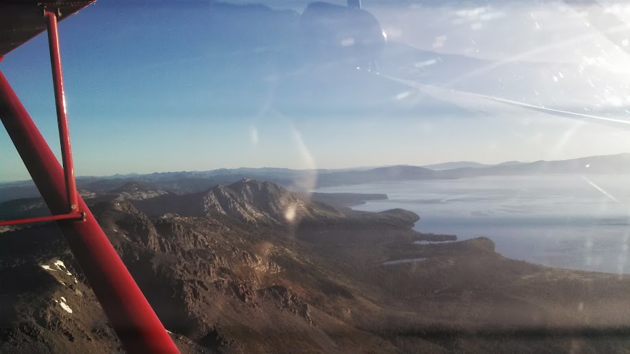
I still had plenty of fuel so didn’t bother topping off.  I elected to escape the 100+ degree heat in their local pilot’s lounge.  Pretty much a small shed with a couch, table and chairs, and most importantly, an air conditioner that could cool an entire house!

I turned on the air and after I cooled down decided to go get a snack out of the airplane.  As I walked back toward my airplane I immediately recognized what caused the unusual turbulence as I was departing Nampa.  My communications antenna was missing from the bottom of my airplane!  Triple dang it!

At this point I knew I really couldn’t continue to Johnson Creek without some way to communicate.  While it is completely legal to do so, it is not wise.  As long as the ring terminals on the antenna wires had not been torn off, I could gerry rig up a new antenna.  I decided to go into town and see what I could scrounge up.


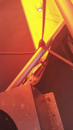
I borrowed the courtesy car and drove to their local True Value hardware store.  I bought a piece of brass welding rod, some duct tape (red to match my airplane), and an assortment of zip ties.  I drove back to the airport after stopping to buy a HUGE cold soda.  After I got back I pulled all my cargo out of the plane so I could get to where the antenna was mounted.  As I had suspected the ring terminals were still intact on the wire ends.  I slipped the center conductor ring terminal over the welding rod and zip tied it in place near the bottom of my new “antenna”.  I then wrapped the entire lower end of the rod in duct tape to insulate it from the ground plane.  A ground plane is a piece of metal that all antennas need to operate properly.  I then zip tied the base of the antenna so that the bottom of the duct tape wrapped antenna was touching the ground plane.  I then used some vise grips to attach the antenna ground wire to the ground plane.

But what I didn’t know was if it really worked.  Luckily there was also a radio scanner in the pilot’s “lounge.”  It was set to scan about 10 frequencies.  A row of red lights would flash in sequence to show which frequency was being scanned.  But I would have to wait until it got darker to see the lights.  I whiled away the hours by having dinner, thinking, and chatting online with an Internet friend who is learning to fly.  It was finally dark enough that I could see the red lights flash when I propped the scanner up in the window of the pilot shack.  I powered up the plane and pressed the push to talk button and viola!  The red lights stopped scanning and one light stayed lit until I released the PTT button!  Then I had a thought, “were my radio transmissions going to be understandable?”  To test that I downloaded a voice recorder app for my smart phone and left it recording next to the scanner.  I went out to plane and transmitted “testing 1-2, testing.”  When I replayed the recording I was perfectly understandable.  My MacGuyver fix worked!

Being a cheap skate I decided to just sleep in the pilot’s lounge that night.  I wish I hadn’t I only got 2 hours of sleep.  But that didn’t matter.  I awoke at first light the next day and was airborne before the sun came up on my final leg to Johnson Creek!

Stay tuned for Part 2!

Worst Cross Country Ever

Not long after becoming a private pilot I decided to go on a fly-out with a group from our airport.  The group was full of seasoned aviators and a couple of cubs; myself and my buddy Bob.  The plan was to fly out from Oakdale down to Laughlin, NV.   The day of the flyout arrived but we had a high overcast and some light rain.  I wasn’t too thrilled about flying so far in these conditions but the more seasoned aviators assured me everything would be fine.  These systems come in from the north and generally don’t extend that far south.  That sounded reasonable to my inexperienced ears so the whole gaggle departed Oakdale to the south.

We got as far as Visalia and then it started raining pretty good.  We decided to stop for lunch and see if the rain would stop.  We called the local Holiday Inn which sent a shuttle to take us over to their restaurant.  We had a great lunch and were in good spirits all around.  We got back to the airport and an hour later the rain stopped.  We all topped off our tanks and were about to head south.  However, one of the most seasoned aviators said that he wasn’t comfortable pushing on in this weather.  He said he was going to be a chicken and head back home.  We bid him goodbye and he headed north while we all headed south.

As we headed south we kept having to climb to get over broken cloud layers.  Soon we had climbed above the overcast and were in bright sunny skies.  However, we were VFR on top.  But the sun seemed so bright and cheery after the clouds and rain below us we felt that the worst was behind us.

Our trusty 172M was purring like a kitten and winging us southeastward over Mohave.  By now we were a long, loose formation.  We had lost site of the 182 in the lead, and the 172 had lost site of us.  The PA-12 was still somewhere below us under the cloud deck.  We began to get concerned because the solid cloud layer was showing no signs of breaking up.  Our seasoned aviator had assured us it would break up soon.  It wasn’t.

The sun was now getting lower in the sky, just above the cloud layer by a few inches and we had finally arrived above Laughlin according to our GPS and our VORs.   We were ecstatic, there was a small hole in the clouds and we could just make out the airport and the hole was just big enough to circle down through.  The 182 and I were orbiting the hole and letting the trail guy in the 170 know that it was there.  He was still 25 miles out and begged us not to leave him up there alone.  We told him we’d circle the hole until he got there.  Then the hole closed up solid.

We asked the 170 where he was… he didn’t know.  So there we were, circling above an airport we couldn’t get to, waiting for a guy who didn’t know where he was, the needles on the fuel gauges were bouncing near empty, and the sun was setting.  The next 5 minutes passed intolerably slowly.  Finally the radio crackles with the sound of the guy in the 170.  “Hey guys!  I’m over the airport I’ll see you on the ground!”

Airport?!  What airport?!

We asked him what airport he was at because we couldn’t get to Laughlin.  No answer.  We were just evaluating our options when he comes back on the radio, “Oh, guess what guys, I’m in Kingman!  Not Laughlin!”  Bob and I looked at each other and then Bob punched Kingman into the GPS.  The 182 radioed that he was flying direct to Kingman.  We answered that we were right behind him.  The 170 radioed back that the sky was clear over Kingman.  We were so relieved!

However, we were about 15 miles south of Kingman and we were still over the cloud layer.  I told Bob we’re going to have to descend through it.  We lined up with the valley heading due north toward the airport and I got on the gauges.  I told him to call the ground as soon as he saw it.  It was the longest 10 seconds of my life. But that about how long I counted in my head before Bob said he had the ground.  I briefly looked away from the instruments to confirm we really did have the ground, we did.

As I turned onto downwind for Kingman the runway lights came on.  The fuel gauge needles were no longer bouncing, they were pegged on E.  I made an unremarkable landing and taxied up to the tie down where the 182 had just finished taking on fuel.  The fuel truck filled me up after I had parked and tied down.  He gave me the receipt and didn’t say a word.  I looked at the number of gallons we took on and estimated we had approximately 20 minutes of fuel left in the tanks.  If that.  I was never so happy to see the end of a flight.

Ironic twist to the story.  Remember the most seasoned aviator that turned back?  That was a good call but… the very next day he was involved in a classic highwing/lowing landing accident.  His 175 was totaled when  Piper Cherokee landed on top of him. Luckily no one was injured but both planes were a complete loss.

Trip to Half Moon Bay

Okay so one of the joys of being a pilot is being able to brag about the places you visit. So here goes. I’ve been wanting to take a longer flight than just flitting around my local area for a while now but the weather hasn’t been cooperating. Today was the perfect day for a road trip, er, air trip! The weather was perfect, a little overcast, temps in the 70’s, no wind to speak of, great early Spring day. Yep. It’s beach weather so I headed to the coast.

I had a hankerin’ for fish so Half Moon Bay was the destination. Specifically, Barbara’s Fish Trap. So I launched into the hazy air of California’s Central Valley.  My direction of flight was to make a beeline for the Altamont Pass, then directly to Sunol, the Dunbarton Bridge, then to squeeze between Palo Alto and San Carlos’ airspace and then pop over the hill to Half Moon Bay. This would keep me out of the San Francisco Class B airspace and out of the numerous Class D’s I just mentioned.

The flight was perfect. A little hazy but that’s what it’s like when we don’t have wind. I scooted over the Altamont, tuned to Livermore and watched for their traffic as I skirted their Class D. Passed over the Sunol grade just as planned, past Mission Peak in Fremont and then headed toward the bay and the Dunbarton Bridge. That’s when my GPS lost signal. Crap. I waited a minute and it came back. Great. As I went feet wet over the bay, my GPS lost signal again. Crap again. I was only about 20 minutes from KHAF at this point. I’d hate to have to turn around now. I didn’t need it to keep from getting lost, I needed to navigate the 1 mile wide corridor between Palo Alto and San Carlos’ respective Class D airspace. The GPS came back and then stayed solid so I continued on.


I kept a close eye on the jumbos on final for San Francisco and also for any traffic coming out of Palo Alto. I finally popped over the hills and made it to the coast. Ah, sweet relief.

There was only one plane in the pattern at KHAF, I announced, joined the pattern, and landed within minutes. The taxi to the tie downs was LONG. It took about 10 minutes to taxi to the tie downs closest to the gate into town. I got there and tied my ship down. Walked up to the gate, wrote the code down on my arm so I could get back in with out walking another mile to the terminal.

Once through the gate it’s only a 5 minute walk to Barbara’s. It’s located right on the beach with a view of the marina. I got there before they opened so I just walked along the piers watching the fishermen unload and listening to the fog horn. I finally got the fish lunch I had been salivating over. Since Cristy wasn’t with me, I bought her a togo box of fish and then headed back to the airport.


The wind had changed so I had to taxi all the way from one end of the field to the other, 15 minutes of taxiing! I finally got to the other end, did my run up and launched into the air to the south toward the marina. I was already at 1000 MSL before I got to the marina so I did a slow 180 to point back to the north.  For my trip home I decided to fly north, skirt San Francisco, fly over the Golden Gate Bridge, and do the north bay tour around to Suisun Bay, past Mt. Diablo, and then into the valley and then beeline home from there. And that’s pretty much what I did.

(The domed building in the lower portion of the picture has special meaning to me. It’s called the Palace of Fine Arts and is where Cristy first kissed me)

The entire trip was uneventful, not really the best sight seeing weather but good flying weather. It took me an hour and 6 minutes to get there and an hour and 20 minutes to get home. This would normally be a 3 hour trip one way through horrendous traffic. I love flying!

Aloha

We just got back from Maui.  I’ve never understood the big deal everyone makes about Hawaii but I have to admit, I really liked Maui.  Unfortunately my daughter got sick while we were there, and she had a broken ankle before we left.  Still we all tried to enjoy the island.  My wife really liked it because the plants, the people, the houses, all reminded her of her homeland.

We’ll definitely be back.

Another Video

Here is a video I made of my trip to Oshkosh in 2005.  It’s mostly a video log of the airports I visited.  But some of it is kind of funny.  You get punchy sitting in a cramped cockpit for 10 hours.


Oshkosh 2005–Part 1

Mercey Hot Springs

I’ve been intrigued with Mercey Hot Springs ever since I found out they had a runway so today I decided to fly out there. I didn’t have time to soak because of engagements later in the day but I certainly had time to fly out there and check things out. To get there I flew due south from Oakdale to the Panoche VOR (PXN) and then hung a right. Mercy Hot Springs is probably 3 miles or so due west of the VOR itself. If you’re going to drive there it’s in the northwest part of Fresno county on Little Panoche Road. Here is their website with directions: https://merceyhotsprings.com/

Today was perfect flying weather, a little hazy but not a breeze in the sky. MHS is located in a draw between some hills. The runway looks to be 2000 feet long or so and hard packed dirt so small tire guys can easily handle this runway. It IS narrow though so make sure you can land straight, you’ve only got a few feet either side of your tires to play with. Also, note that there are quite a few gopher holes in the parking area so if you do have small tires, be careful. My 6.00×6’s were fine.

As I approached the strip I was trying to come up with a story as to why I landed in case I wasn’t welcome. As I flew over the strip I could see another plane parked next to the runway so I figured this was a green light. I flew a wide left pattern so I wouldn’t overfly the guests and ruin their peace and quiet. Incidentally this met with the owner’s extreme approval as I later found out. The approaches are mostly clear and not noting any wind I elected to land from south to north. There was a mild breeze on the ground that was from the north so this proved to be a good idea. As I came down short final I noticed that there is a small hill in front of the runway. It isn’t very high but you’ll want to be aware of it. I skimmed over it and landed easily on the hard packed dirt.

I taxied back and parked next to a Murphy Rebel. The pilot and his copilot were there. I asked him if it was okay to land here. He indicated that it probably was but he always calls ahead to ask. I figured it was better to ask forgiveness so I headed into the registration office after pushing my plane back into the parking area.

I walked over to the office and was warmly greated by a man a woman sitting in the office. I asked them if was okay to fly in. He said it was fine but legally he had to tell me the runway was closed. He asked if I saw the X’s. I told him I did and had parked next to one of them. He said that was fine, it’s just that the county wants the X’s visible from the air. He said, “Here’s the deal, if you’re flying by and you hear a funny noise or you want to check an aileron or something, feel free to land and check your plane out. If everything seems fine and you’d like to camp or soak, you’re welcome to do that.” Then he handed me a brochure and explained the various facilities. Very sociable and friendly guy as was his wife.


The registration office is the Spanish architecture building on the left.


The pool is kept at 85 degrees!


Tent camping area.  There is also a place for full RV hookups.  You can rent a cabin if you really want to travel light.

I’ll definitely be back when I have time to soak.

My plane is on Google Earth

Just found out that Google’s eye in the sky took a photo at Oshkosh while I was there.  Here is a picture of my plane and also the plane of a friend, Mike Terpstra.  If you zoom into the airport in Oshkosh, Wisconsin, you will find my plane!  Here is a photo.  My plane is the red one, Mike’s is the silver one…


googleearthphoto

Airplane Camping with Scotty

I wanted to take one more camping trip this year before it got too cold.  After all in the plane so this seemed like the best time to go.  I put out the word on another forum I belong to and asked if there were any takers in my neck of the woods for a camping trip to Gravelly Valley (1Q5).  A friend of mine from EAA Chapter 90,Mike,  and also a friend from the other forum, Joey, decided they wanted to go too. 

Gravelly Valley Airport (1Q5)


Columbia Airport (O22)

So we decided to head up there this past Saturday.  The plan was to meet up enroute to Gravelly Valley over Clear Lake.  However, a thick marine layer was covering the hills we needed to get to.  Joey and I decided to head for our alternate of Columbia (O22).  I tried to get hold of Mike but he had already departed.  I hung out at my airport for a few hours while getting text updates from Joey that it was looking more and more like we would head to our alternate.  Finally I got a phone call from Mike who had flown all the way up to Gravelly and confirmed that it was socked in.  Since Mike and his son had their heart set on fishing they headed south toward Lake Isabella.  Joey, my son Scotty and I, headed up to Columbia.

IMG_3273

Columbia has two runways, a paved runway and a grass runway.  The campground is located next to the grass runway.  I got up there about an hour before Joey arrived so I set my camp up.  Since I had forgotten my tiedowns I had to park closer toward the paved runway. I hung out along the runway and watched landings until Joey arrived.

After Joey had set up camp we took a walk into town.  Columbia is an old preserved mining town and a state park.  Actors in period costume stroll the streets, you can ride a stagecoach, pan for gold, or like the three of us, eat.  Most of the restaurants in the park are a little spendy so we walked one block out of the park and ate at El Jardin, one of my favorite Mexican restaurants. 

IMG_3275


IMG_3278

After dinner we hiked back to the airport along the nature trail that runs between town and the airport.  Joey went out for a quick 30 minute sunset flight.  I stayed in my chair along the runway and smoked my pipe.  Joey landed and after admiring the sunset we went and talked to our neighbors, a FA-18 pilot on leave.  He’s normally flying off the USS Ronald Reagan.  Nice guy.  By then the sky was black, full of stars, and all of us were sleepy.


The next morning we packed up and took off on the grass runway, and then dove over the ridge into the ravine that leads to New Melones Resevoir.  After Joey found me we circled round, flew through the "star wars trench", a huge spillway that protects the New Melones Dam.  Then Joey took some air to air shots of my plane as we flew down river toward Oakdale.  The plan was for my to offload my gear and then continue on with him to a fly-in at Rio Vista.  However, my son, who is a special needs guy, had enough. He was ready to head home.  So as Joey headed skyward again, Scotty and I drove on in to town and to the local IHOP.

IMG_3310


IMG_3308

It was a short trip by air, but still a lot of fun for my son and for myself too of course!

Oshkosh Trip 2011 Part 4

Thanks to being able to use the courtesy car in Idabel I was able to get to the airport and have the plane ready to go by first light.  The air was warm and heavy with humidity.  I took off as soon as it was light enough to see the taxiways.  Idabel doesn’t have parallel taxiways so I back-taxied to runway 20 and launched into the heavy air.  The sky was clear and hazy but at least there was no trace of the headwinds I had been fighting on my way down to Oklahoma.  I turned westward toward my first fuel stop at Decatur Texas.

Two and a half hours later I was passing over Lake Texoma and shortly after that I was on the ground in Decatur and fueled up.  It was already getting hot at 8:30 in the morning.  The high temperature for that day was forecast to be 107 so I got out of there as quickly as I could. 


The next stop was Sweetwater Texas.  I was somewhat concerned that if I landed I would be stuck for a while due to the fact that Sweetwater is surrounded by miles and miles of windmills.  Obviously a windy area.  After fueling up I asked for courtesy car and a lunch recommendation.  The woman at the FBO was pointed tying to get me to not take the car and eat at the cafeteria across the street at the college.  Then she told me about a diner about 10 miles up the highway in Roscoe Texas called Retta Mae’s Diner. I elected to go here and I am glad I did!  Not only did I have the best hamburger I have had in years, but the waitress really made you feel welcome.  She was working hard because it was crowded but she always stopped back by with “you doing okay sugar?” or “you need a refill, honey?”  A diner with pretty waitresses addressing you with endearing terms and bringing you delicious food is a fine diner indeed.

After lunch I headed back to the airport.  It had gotten hotter and the wind had kicked up.  I elected to stop for the day.  The woman at the FBO told me that the local La Quinta Inn would offer free pickup and drop off so I called them and about 45 minutes later I was tossing my suitcase on the hotel room bed.  The next morning at 5am I was packed and down at the front desk.  They drove me back out to the airport and at sunrise I was back in the air headed west again.

My first fuel stop was Carlsbad New Mexico.  After fueling up at Carlsbad I had to angle south toward the Mexico border near El Paso to clear the White Sand Missile Range restricted airspace.  This was kind of a fun flight for me as I have worked at WSMR several times.  It was fun to see it from the air.  Once clear of the restricted airspace I pointed toward Las Cruces New Mexico.  It was hot and bumpy when I landed in Las Cruces so I stopped for the night.  No courtesy car is available in Las Cruces, however, they will rent you a car.  I rented the car and went to find a hotel for the night.  I spent the night in an unimpressive hotel.

The next morning I took off again at first light and headed west yet again.  I flew almost due west toward Tuscon and made Marana Regional my first fuel stop.  This is a great little field with a very busy and popular restaurant on the field.  I was tempted to stop and eat breakfast here but I was getting really homesick.  I also wanted to put as many miles behind me as I could before the bumps started.  I gassed up and pointed my nose toward Blythe California. 

Two hours later I was making a long straight in approach to Blythe.  My GPS was showing storms ahead and I could see a wall of clouds off in the distance.  I landed and got gas and then went into the FBO to get a cold drink.  It was about 100 degrees outside and there were thunderstorms to the west.  I knew I wouldn’t be able to continue that day.  Inside the FBO was a couple who were trying to get to Visalia which is about 90 miles south of where I was trying to go.  They were going to wait around a while to see if the storms cleared up.  I asked for and got the courtesy car and went into town to find a hotel.  I checked into a clean Best Western and took a shower and a nap.  I realized I had left my keys in the airplane so I drove back out to the airport.  I drove up to my plane and noticed that the other couple’s Cessna 210 was still there.  As I was getting back into the courtesy Suburban I saw the man walking toward me on the ramp.  I knew what he wanted.  I invited him to hop in and took him and his wife to their hotel.  After agreeing to meet at 5:30 the next morning and securing a promise to split the fuel cost for the courtesy car I took them to their hotel.

I was at their hotel the next morning at 5:30am and as promised they were there and ready.  We drove back out to the airport and I was in the air by 6:15am.  I headed west again for what I hoped would be my last day of flying.  My first fuel stop was Rosamond near Lancaster.  I normally stop at Fox Field when I’m in this neighborhood but I thought a smaller airport could use my money.  I made a straight in approach to Rosamond and fueled up at the finicky fuel pump.  There was no sign of the previous day’s thunderstorms and there was no wind.  I thanked my Maker for the lack of weather and then launched west to make my last climb over the hills and then into the Central Valley.  I cleared the hills and honestly Bakersfield never looked so good.  I finally turned northwest and an hour and a half later I was on the ground back home in Oakdale California.

Epilog coming in a few days.