My First Trip to Johnson Creek Airport (3U2)–Part 1

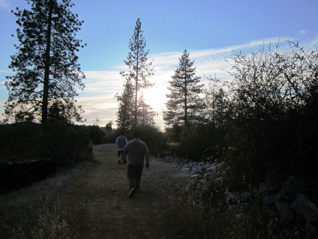
For those who have never heard of Johnson Creek Airport it is considered the gateway to mountain flying in Idaho.  It is like the Ritz Carlton for back country aviators.  It is a beautifully manicured 3400 foot long, 150 feet wide grass runway near Yellow Pine, Idaho.  Never heard of Yellow Pine?  I’m not surprised, it’s a long way from anywhere.

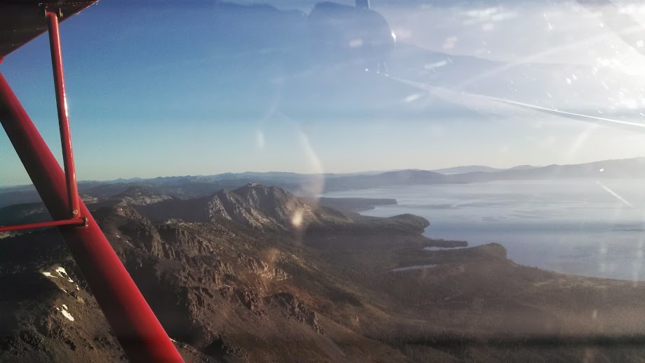
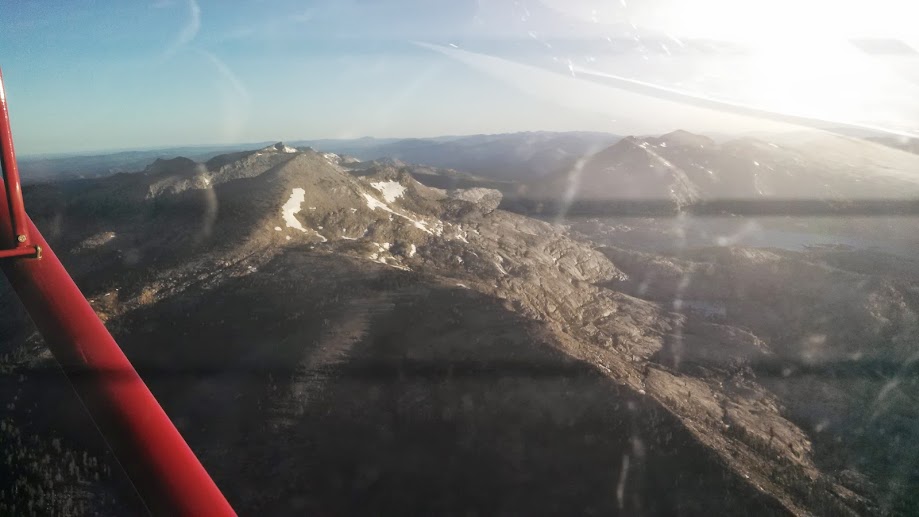
My day started at 0430 Pacific Time.  I had already packed my camping equipment in the plane and fueled up.  All I needed to do was throw my suitcase in the plane, update my weather briefing, and go.  I actually should have gotten an earlier start because as I was climbing out over the Sierras the sun was coming up.  This made the peaks particularly difficult to see as I was climbing almost directly into the sun.  As I leveled off at 9,500 MSL over Lake Tahoe I turned toward Lovelock, Nevada I at least got to turn to where the sun was hidden by a tube in my cockpit.

About two hours after I departed Oakdale I was landing at Derby Field, Lovelock, NV.  There isn’t much there other than an old MIG and a fuel pump.  I topped off and continued on as fast as I could.


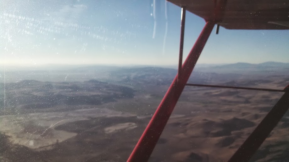
The scenery pretty much stayed the same for the next two hours.  High desert punctuated by low mountains all the way up to the Boise, ID area.

I stopped in Nampa, ID for fuel.  It took me forever to figure out how the fuel pumps worked there.  How many different places can they think to hide a fuel pump switch?  I topped off my tanks and taxied out to depart.  It was hot and the density altitude was pretty high so it was a long takeoff run followed by a listless climb out.  I felt some odd turbulence as I was climbing out but didn’t think much of it.  I was also unable to clearly hear the AWOS (Automated Weather Observation System) at Nampa.  Oh well, continue climbing out and heading toward Cascade, ID to top off once again before heading into Johnson Creek.

As I got closer to the mountains it started getting really bumpy.  I looked at my phone to see what time it was; 1:15pm.  Dang.  I really should have started earlier.  As the bumps got worse the advice given me about Johnson Creek kept ringing in my head, get it on the ground by 11am.  Double dang.  I elected to divert to Emmett, ID and wait out the heat.  I enjoyed a bumpy flight all the way into Emmett and made an uneventful landing.

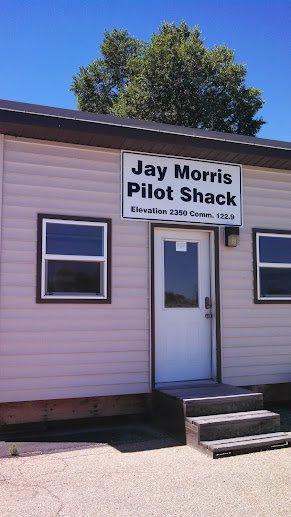
I still had plenty of fuel so didn’t bother topping off.  I elected to escape the 100+ degree heat in their local pilot’s lounge.  Pretty much a small shed with a couch, table and chairs, and most importantly, an air conditioner that could cool an entire house!

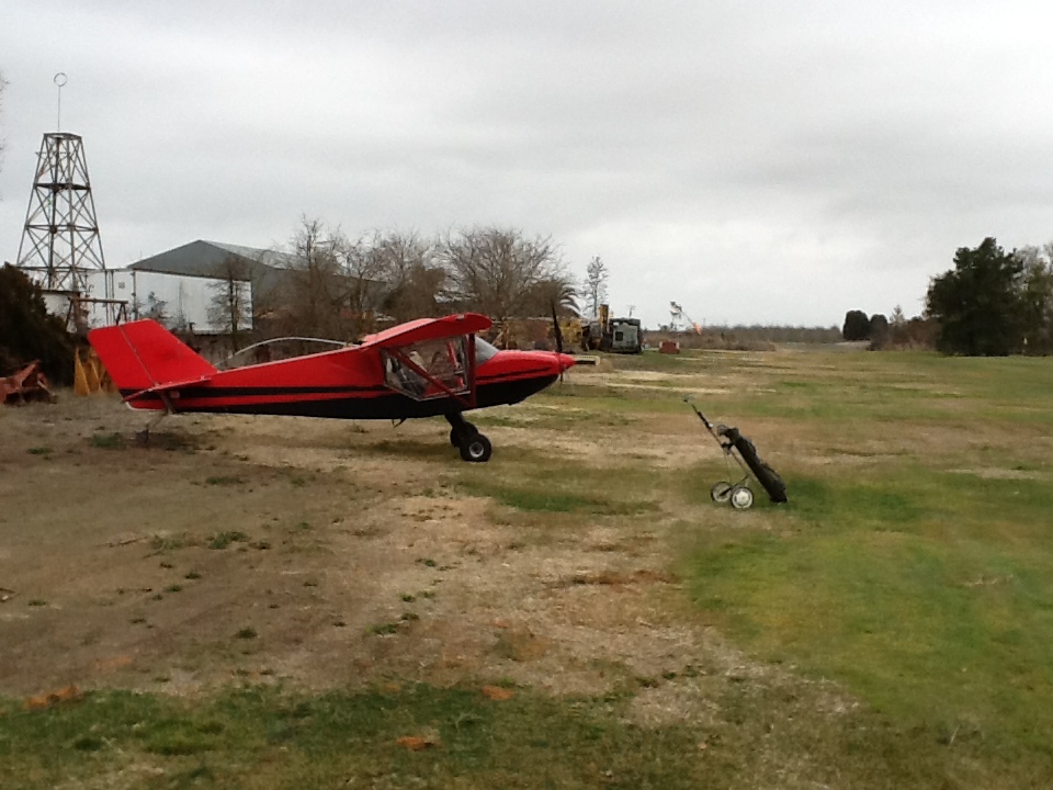
I turned on the air and after I cooled down decided to go get a snack out of the airplane.  As I walked back toward my airplane I immediately recognized what caused the unusual turbulence as I was departing Nampa.  My communications antenna was missing from the bottom of my airplane!  Triple dang it!

At this point I knew I really couldn’t continue to Johnson Creek without some way to communicate.  While it is completely legal to do so, it is not wise.  As long as the ring terminals on the antenna wires had not been torn off, I could gerry rig up a new antenna.  I decided to go into town and see what I could scrounge up.


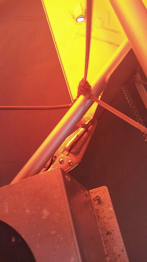
I borrowed the courtesy car and drove to their local True Value hardware store.  I bought a piece of brass welding rod, some duct tape (red to match my airplane), and an assortment of zip ties.  I drove back to the airport after stopping to buy a HUGE cold soda.  After I got back I pulled all my cargo out of the plane so I could get to where the antenna was mounted.  As I had suspected the ring terminals were still intact on the wire ends.  I slipped the center conductor ring terminal over the welding rod and zip tied it in place near the bottom of my new “antenna”.  I then wrapped the entire lower end of the rod in duct tape to insulate it from the ground plane.  A ground plane is a piece of metal that all antennas need to operate properly.  I then zip tied the base of the antenna so that the bottom of the duct tape wrapped antenna was touching the ground plane.  I then used some vise grips to attach the antenna ground wire to the ground plane.

But what I didn’t know was if it really worked.  Luckily there was also a radio scanner in the pilot’s “lounge.”  It was set to scan about 10 frequencies.  A row of red lights would flash in sequence to show which frequency was being scanned.  But I would have to wait until it got darker to see the lights.  I whiled away the hours by having dinner, thinking, and chatting online with an Internet friend who is learning to fly.  It was finally dark enough that I could see the red lights flash when I propped the scanner up in the window of the pilot shack.  I powered up the plane and pressed the push to talk button and viola!  The red lights stopped scanning and one light stayed lit until I released the PTT button!  Then I had a thought, “were my radio transmissions going to be understandable?”  To test that I downloaded a voice recorder app for my smart phone and left it recording next to the scanner.  I went out to plane and transmitted “testing 1-2, testing.”  When I replayed the recording I was perfectly understandable.  My MacGuyver fix worked!

Being a cheap skate I decided to just sleep in the pilot’s lounge that night.  I wish I hadn’t I only got 2 hours of sleep.  But that didn’t matter.  I awoke at first light the next day and was airborne before the sun came up on my final leg to Johnson Creek!

Stay tuned for Part 2!

Saturday morning golf

I’ve been grounded for almost a month trying to get over the Flu.  My ears and lungs had finally cleared and I really needed to get some fresh air so I hoped in my flying golf cart and flew out to the links.  Here is a video of the approach and landing at JB Golf (CN29).

Another great day golfing

I flew to Farmington again today to play golf.  This is the second time I’ve flown there in the past couple of weeks and both times it was cloudy and drizzly.  That didn’t matter though.  It is still fun to land on that grass, hop out, grab my clubs and play 9 holes.  I’m the worst golfer ever but I do enjoy the walk.

Back at JB Golf

Many years ago I used to fly an Aeronca Champ.  I loved landing it off airport.  For years I used to fly to a small golf course in Farmington called JB Golf.  It was created by a man who loved golf and flying.  I was introduced to this strip by Jerry Hansen.  He used to fly his 175 and then his Pacer in to this strip.  I tagged along in my Champ.  Well, time passed and Jerry wasn’t able to fly into JB any more.  I built an RV-4 which I never could slow down adequately to land safely at JB.  I really missed flying in to JB and that is one of the big reasons I sold my RV-4 and built my new plane; the Coyote.    Today I was finally able to find time to clean up my golf clubs fly in to JB.

The owner loves to have airplanes fly in so if you’re a golfer and you have reasonable short/soft field skills you are welcome here.  The strip is located just east of Stockton Metro Airport in central California.  It is marked on the SFO sectional as J-B.  It is listed as private but pilots with appropriate skills are welcome to land.

Here are a few  pictures from my trip today.

Image

Image

Image

Image

Mercey Hot Springs

I’ve been intrigued with Mercey Hot Springs ever since I found out they had a runway so today I decided to fly out there. I didn’t have time to soak because of engagements later in the day but I certainly had time to fly out there and check things out. To get there I flew due south from Oakdale to the Panoche VOR (PXN) and then hung a right. Mercy Hot Springs is probably 3 miles or so due west of the VOR itself. If you’re going to drive there it’s in the northwest part of Fresno county on Little Panoche Road. Here is their website with directions: https://merceyhotsprings.com/

Today was perfect flying weather, a little hazy but not a breeze in the sky. MHS is located in a draw between some hills. The runway looks to be 2000 feet long or so and hard packed dirt so small tire guys can easily handle this runway. It IS narrow though so make sure you can land straight, you’ve only got a few feet either side of your tires to play with. Also, note that there are quite a few gopher holes in the parking area so if you do have small tires, be careful. My 6.00×6’s were fine.

As I approached the strip I was trying to come up with a story as to why I landed in case I wasn’t welcome. As I flew over the strip I could see another plane parked next to the runway so I figured this was a green light. I flew a wide left pattern so I wouldn’t overfly the guests and ruin their peace and quiet. Incidentally this met with the owner’s extreme approval as I later found out. The approaches are mostly clear and not noting any wind I elected to land from south to north. There was a mild breeze on the ground that was from the north so this proved to be a good idea. As I came down short final I noticed that there is a small hill in front of the runway. It isn’t very high but you’ll want to be aware of it. I skimmed over it and landed easily on the hard packed dirt.

I taxied back and parked next to a Murphy Rebel. The pilot and his copilot were there. I asked him if it was okay to land here. He indicated that it probably was but he always calls ahead to ask. I figured it was better to ask forgiveness so I headed into the registration office after pushing my plane back into the parking area.

I walked over to the office and was warmly greated by a man a woman sitting in the office. I asked them if was okay to fly in. He said it was fine but legally he had to tell me the runway was closed. He asked if I saw the X’s. I told him I did and had parked next to one of them. He said that was fine, it’s just that the county wants the X’s visible from the air. He said, “Here’s the deal, if you’re flying by and you hear a funny noise or you want to check an aileron or something, feel free to land and check your plane out. If everything seems fine and you’d like to camp or soak, you’re welcome to do that.” Then he handed me a brochure and explained the various facilities. Very sociable and friendly guy as was his wife.


The registration office is the Spanish architecture building on the left.


The pool is kept at 85 degrees!


Tent camping area.  There is also a place for full RV hookups.  You can rent a cabin if you really want to travel light.

I’ll definitely be back when I have time to soak.

Merry Christmas

Got a really neat Christmas present for my plane this year.  An ice chest!  How is that really neat?  The fact that it fits perfectly into the cockpit baggage compartment of my plane.  I’m ready for some flying picnicking and camping this year!

photo (1)


photo (2)


photo (3)

Friday Flight

I had a vacation day scheduled for this past Friday.  I needed to decompress after a stressful week so guess what I did?   That’s right!

The day started out perfect.  No wind, no bumps and outstanding visibility.  A beautiful fall day in the valley.

2011-11-04_09-09-58_687

I decided to head over to San Francisco Bay via Suisun and then San Pablo Bay.  As I flew past Lake Byron I could see that there were clouds starting to build up.

2011-11-04_09-30-08_486


The clouds started getting thicker near Suisun Bay and it started getting pretty bumpy.  Even though San Pablo bay in the distance is clear it was getting very bumpy and I could see SF Bay was clouded in.

2011-11-04_09-41-21_926


It was too nice  a day to fight the bumps so I turned eastward to look for breakfast.

2011-11-04_09-58-32_74


Oh look!  Here’s a place to park and it’s right next one of my favorite breakfast destinations.

2011-11-04_10-32-47_100


Yes!  The Lodi Café at the Lodi Airport.  You can see that the previously clear valley was starting to be dotted by low clouds.  The bumps had followed me from the bay area to the valley.  I decided to call it a day after two hours of flying.  I flew back to Oakdale and by the time I had the hangar shut it was getting pretty cloudy and the wind had starting kicking up.  I think I made a good call.

2011-11-04_11-04-28_726

My plane is on Google Earth

Just found out that Google’s eye in the sky took a photo at Oshkosh while I was there.  Here is a picture of my plane and also the plane of a friend, Mike Terpstra.  If you zoom into the airport in Oshkosh, Wisconsin, you will find my plane!  Here is a photo.  My plane is the red one, Mike’s is the silver one…


googleearthphoto

Airplane Camping with Scotty

I wanted to take one more camping trip this year before it got too cold.  After all in the plane so this seemed like the best time to go.  I put out the word on another forum I belong to and asked if there were any takers in my neck of the woods for a camping trip to Gravelly Valley (1Q5).  A friend of mine from EAA Chapter 90,Mike,  and also a friend from the other forum, Joey, decided they wanted to go too. 

Gravelly Valley Airport (1Q5)


Columbia Airport (O22)

So we decided to head up there this past Saturday.  The plan was to meet up enroute to Gravelly Valley over Clear Lake.  However, a thick marine layer was covering the hills we needed to get to.  Joey and I decided to head for our alternate of Columbia (O22).  I tried to get hold of Mike but he had already departed.  I hung out at my airport for a few hours while getting text updates from Joey that it was looking more and more like we would head to our alternate.  Finally I got a phone call from Mike who had flown all the way up to Gravelly and confirmed that it was socked in.  Since Mike and his son had their heart set on fishing they headed south toward Lake Isabella.  Joey, my son Scotty and I, headed up to Columbia.

IMG_3273

Columbia has two runways, a paved runway and a grass runway.  The campground is located next to the grass runway.  I got up there about an hour before Joey arrived so I set my camp up.  Since I had forgotten my tiedowns I had to park closer toward the paved runway. I hung out along the runway and watched landings until Joey arrived.

After Joey had set up camp we took a walk into town.  Columbia is an old preserved mining town and a state park.  Actors in period costume stroll the streets, you can ride a stagecoach, pan for gold, or like the three of us, eat.  Most of the restaurants in the park are a little spendy so we walked one block out of the park and ate at El Jardin, one of my favorite Mexican restaurants. 

IMG_3275


IMG_3278

After dinner we hiked back to the airport along the nature trail that runs between town and the airport.  Joey went out for a quick 30 minute sunset flight.  I stayed in my chair along the runway and smoked my pipe.  Joey landed and after admiring the sunset we went and talked to our neighbors, a FA-18 pilot on leave.  He’s normally flying off the USS Ronald Reagan.  Nice guy.  By then the sky was black, full of stars, and all of us were sleepy.


The next morning we packed up and took off on the grass runway, and then dove over the ridge into the ravine that leads to New Melones Resevoir.  After Joey found me we circled round, flew through the "star wars trench", a huge spillway that protects the New Melones Dam.  Then Joey took some air to air shots of my plane as we flew down river toward Oakdale.  The plan was for my to offload my gear and then continue on with him to a fly-in at Rio Vista.  However, my son, who is a special needs guy, had enough. He was ready to head home.  So as Joey headed skyward again, Scotty and I drove on in to town and to the local IHOP.

IMG_3310


IMG_3308

It was a short trip by air, but still a lot of fun for my son and for myself too of course!

Backcountrypilot.org get together

Today I went to a mini fly-in with some of the guys from Backcountrypilot.org.  We met up at Truckee airport (KTRK) and departed from there to take a tour of some of the local off airport spots one of the members lands at.  As all pilot stories start out, I got up at O-dark-30 and drove out to the airport to get my plane ready.  It just started getting light at 6am as I departed and turned north into the Sierra Nevada mountains.

It was still as glass this morning as I climbed into the foothills.  I tuned my radio to the predetermined frequency and radioed to see if Emmet, another Backcountrypilot.org guy and fellow Rans Clan member, was airborne yet.  He responded that he was going to fly by some friends that were camping and then he’d fly up to Truckee.  I held my northbound course for another hour watching the sun rise over the peaks to the east.  Soon the pristine waters of Lake Tahoe were on my right and as I crested one more peak Truckee slid into view.

2011-09-03_07-06-55_120

2011-09-03_07-02-02_997

I made a crosswind entry to runway 19 and made a greaser.  I know, weird huh?  I taxied to the south side of the field and found the other guys.  I fueled up and show up for the briefing which was just finishing.  Kevin, (AKTahoe on Backcountrypilot.org) gave me a quick rundown of the plan.  In a nutshell it was tune to 124.20 and follow everybody.  Roger that.  I got back in my plane and followed the other guys to runway 01.  It was really cool to see 6 taildraggers all taking off one right after the other into the crisp blue Sierra skies.

2011-09-03_08-16-29_851

2011-09-03_08-17-14_826

Being low man on the totem pole I pulled into the rear of the loose gaggle of planes.  We first flew past a sweet strip next to one of the three reservoirs (I think it was Stampede) near Truckee. Kevin then took us to a strip he calls Mile-Hi and a Half (or was it Mile and a Half-Hi, don’t remember now.)  He gave us a quick rundown on how to make the approach. That is definitely not a strip for beginners like me.  I circled over and thought to myself, “Yeah, mmm, hmmm.  That’s nice.  Next!”

We then flew down into the valley north of Truckee to a strip called Totem.  This was my favorite.  It was really smooth and long and I made a dang fine landing there WITH EVERYONE WATCHING.  This was my first time taking this airplane off-runway!  Kevin gave us the rundown on the strip and a brief history before some of the guys went to land at Totem 2 which is about 1/2 mile to the SW.  The two runways basically make an L shape.  I hung around at Totem 1 and talked to one of the guys (John in the tricycle with big tires?)  I finally took off and circled over head to take a look at Totem 2.  Kevin said I could make it in there and he was right.  I just felt that there was no need to get too ambitious on the first off airport landings I had made in my new plane.

2011-09-03_08-49-14_794

2011-09-03_08-49-30_919

2011-09-03_08-53-29_194

2011-09-03_08-53-43_538

2011-09-03_08-56-17_859

Next we flew over to a strip called Bumpy Barn.  Kevin recommended this strip only to those with big tires and more experience.  Point taken, I’ll just look at it from the air.  From here it was about a 2 minute flight to our next landing spot at a strip called The Ranch.  I was able to make it in there with no issues by following Kevin’s guidance, “land past the patch of green, stay to the right, there’s a gully on the left.”  This strip was a little rougher than Totem but still manageable.  My landing wasn’t quite as good but everyone was too busy to notice (I hope.)  I was the second plane down this time and when I turned to park I saw 3 other planes taxiing behind me!  These guys are good!

2011-09-03_09-47-44_469

2011-09-03_09-47-53_573

2011-09-03_09-47-59_562

2011-09-03_09-48-07_406

The Ranch is by far the more picturesque of the first strips the group hit today.  Kevin explained that it’s for sale so if you really want a beautiful home with an airstrip in beautiful country, Kevin can point you in the right direction.  Some of the guys departed to go back and land at Bumpy Barn.  I decided to try to shoot another landing at The Ranch and taxied out to take off.  The take off changed my mind about landing again!  For the reason why you have to understand that my plane has a solid tailwheel which has very poor shock absorption qualities.  I also have spring steel landing gear and we all know what springs do right?  So I start my take off roll and everything is looking good and then I hit a small bump and bounce into the air.  I’m not going fast enough to fly so I come back down and bounce a couple more times.  Then I hit another bump and up I go and down I go.  Then I hit a third bump and this was big enough to throw me so far skyward such that I didn’t touch down again.

I checked the clock and found that it was time for me to head back.  I radioed the group and told them that I had to depart the area and they wished me well.

Backcountrypilot.org guys: If at all possible you must come to Truckee and let Kevin take you on one of his circuits.  He is very knowledgeable about this area and is a great tour guide.  I really wish I could have stayed longer.  Thanks again Kevin for a great introduction to the Truckee area.  I’m going to brush up and I will definitely be back for the camp out next time!

2011-09-03_12-02-02_49

Here is the link to my Spot GPS Messenger tracking page if you’d like to see where we went: http://share.findmespot.com/shared/faces/viewspots.jsp?glId=0HrtlSyl3ynThznO2mQli5bKoUA7mtSZx